Identity area
Reference code
DOC_20190826_10_VG_59
Title
SN
Date(s)
- 2019 (Creation)
Level of description
Item
Extent and medium
Image numérique
Context area
Name of creator
Archival history
Immediate source of acquisition or transfer
Content and structure area
Scope and content
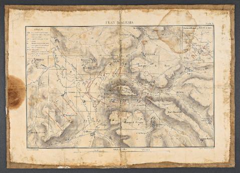
Plan d’Alésia. Carte de travail pour les fouilles menées à Alise-Sainte-Reine, sans date [1861-1865]. Papier collé sur toile. H. 0,36 m ; l. 0,505 m.
Centre des archives, fonds topographique, Côte-d’Or, Alise-Sainte-Reine.
Prise de vue après restauration.
Appraisal, destruction and scheduling
Accruals
System of arrangement
Conditions of access and use area
Conditions governing access
Conditions governing reproduction
©MAN/Valorie Gô
Language of material
Script of material
Language and script notes
Physical characteristics and technical requirements
Finding aids
Allied materials area
Existence and location of originals
Existence and location of copies
Related units of description
Notes area
Alternative identifier(s)
Access points
Subject access points
Place access points
Name access points
- Napoléon III (Subject)
- Commission de Topographie des Gaules (Subject)
- Stoffel, Eugène (Subject)
- Jules César (Subject)